
Medicine Bow to Medicine Lodge
WY SR-130 nw to WalcottI-80 west to Rawlins
US 287 nw to Sweetwater Station
CR- 135 to Riverton
SR-26 to Shoshoni
SR-20 to Manderson
CR-31 to Hyattville

It was a long day of driving, because I stopped at every podunk historical marker along the way. There have been lots of bikers out and about; I assume that they're on their way to Sturgis. Lots of beautiful bikes and strange people. And, before I forget, they give out cookies and fruit punch or coffee at the Wyoming rest stops.
It was beautiful outside when I left Silver Lake. Everything opens up when you leave Medicine Bow, and the vistas are sometimes overwhelming. Every once in a while, I was compelled to pull over to the side of the road, stop the car, and just breathe it all in. And fumble with the cameras: a photographer I am not. The digital has no telephoto lens on it, and invariably I always had the wrong lens on the Canon for whatever I wanted to photograph. It's all just too much for my brain.
Saratoga is kind of a neat little town. Everything (including the Springs) was closed when I drove through, since it was Sunday morning. I was hoping for a bath in the "healing waters", but no luck. Too bad. I needed one.
I toured the ruins of Fort Steele, which was not really the site of much action; it was built in 1868, and 300 soldiers were sent there to guard the Union Pacific Transcontinental Railroad against attack from Indians. They didn't have to fight many Indians, but they fought some Chinese who defected from the ranks of the railroad workers. The fort was occupied by the government until 1886, and then it became a mercantile. It sits in a pretty spot at a bend in the North Platte River.
I drove over the Sweetwater River and the Badwater River. And about a hundred other rivers. There is an ice slough on 287, where water used to collect and freeze under the prairie grass. The grasses insulated the ice, and sometimes it didn't melt until the end of summer. Can you imagine how thrilled you would've been to have been crossing the Oregon Trail in the hot summer, and to have come upon ICE out in the middle of nowhere? Unfortunately, the water has been diverted out of the slough for irrigation. It exists no more.
The Sweetwater Valley is wide open, and as I drove, my mind wandered over all of the people who had crossed via the Oregon Trail. I saw Split Rock, which was one of three successive landmarks for travelers in this area, the first being Independence Rock, and the second Devil's Gate. Split Rock appears as a deep cleft in the summit; it looks like a gunsight from either the east or the west approach. South of Split Rock, along the Sweetwater, there used to be a Pony Express station from 1860-61.
I saw my first antelope of the trip on this leg, and saw ranchers riding fence in their trucks and on horseback. There were quite a few cows who had escaped. And I killed my first bird of the trip with the EVC. And I hope it's my last. This was pretty gross, but kind of strange; he died in perfect open wing formation centered on the grill of the car under the VW logo.
Shoshoni is a pretty bland town, regardless of its beautiful name. I passed on eating at a diner in town that advertised "Bicuits and Gravy and Bait." I also did not take an advertised shortcut through Rattlesnake Pass.
Wind River Canyon is breathtaking.
There's about 16 miles of 2500 foot high cliffs rising out of the water, and
the state of Wyoming has graciously labeled the canyon walls from the Precambrian
to the Mesozoic for the geologically stupid. Like me. :-) Early explorers
didn't know that the Bighorn River and the Wind River were one and the same,
and named the cave at the ca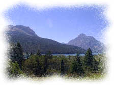 nyon
mouth "The Wedding of the Waters." There is a railroad track that runs the
length of the canyon. It would be a harrowing trip, to say the least.
nyon
mouth "The Wedding of the Waters." There is a railroad track that runs the
length of the canyon. It would be a harrowing trip, to say the least.
Thermopolis is just a normal small western town. I don't know what I expected, but there wasn't much there. It was too hot to do the hot springs, but I got a picture.
When I was visiting Fort Steel I picked up a little historical brochure and read about the Medicine Lodge archeological site. I just serendipitously noticed the blurb for campsites, or I never would've known to camp here. It is not listed in my camping bible, The Complete Guide to Rocky Mountain Camping. I have carried this book around for years, and it is tattered and littered with notes about campgrounds. I wouldn't come west without it.
ANYWAY, it was getting late and Medicine Lodge is way off the beaten track, but I decided to risk it, and headed off in that direction. I am so glad that I did; I couldn't have picked a better spot to take some time to regroup and relax for a little while. There are miles and miles of hiking trails and a small interpretation center and beautiful backroads to bike. The river is clear and fairly shallow and very user-friendly. Someone has dammed up a bend right by my campsite that makes a great swimming hole. And it's free. I may stay a while.
![]()
![]()